

The Science of Where
Esri is the global market leader in geographic information system (GIS) software, location intelligence, and mapping.
Since 1969, we have supported customers with geographic science and geospatial analytics, what we call The Science of Where.
We take a geographic approach to problem-solving, brought to life by modern GIS technology. We are committed to using science and technology to build a sustainable world.
ARCGIS
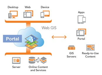
ArcGIS Enterprise provides a system for mapping, visualization, data management, and analytics, as well as a flexible deployment model allowing for use on-premises, in the cloud, and on virtual machines. A base ArcGIS Enterprise deployment includes several components that are designed to work together.The ArcGIS Enterprise solution will provide the following functionalities.
- Publishing fast, intuitive web maps tailored to the organizational audience, dramatically strengthening business and resource decisions with real-time geo-intelligence.
- Centrally managing spatial data, providing better data security and integrity for the most important information assets.
- Simplifying access to large volumes of data resources, significantly reducing storage costs and data processing overhead.
ArcGIS Enterprise Server is a back-end server software component of ArcGIS Enterprise that makes your geographic information available to others in your organization and, optionally, anyone with an internet connection. This is accomplished through GIS services, which allow a server computer to receive and process requests for information sent by other devices.
The primary way of configuring it is as part of an ArcGIS Enterprise deployment in which ArcGIS Enterprise Server is federated with an ArcGIS Enterprise Portal. This is the deployment that most users should use. In this deployment, geographic data is made available through layers and web maps in the portal. Those items can then be consumed in a variety of apps, including browser-based web apps and native apps on mobile devices, with little to no custom development required.
ArcGIS Enterprise Server requires a machine capable of running a 64-bit operating system. Its architecture is scalable, so you can add multiple machines if additional processing power is needed.
ArcGIS Enterprise can be licenses in two editions – Standard and Advanced. Each successive edition offers additional functionality
- Standard—With the Standard edition, this includes geodatabase management and the ability to publish (but not edit) feature services for map visualization and query. You also get the geometry service and the ability to publish geodata services and all the GIS web service types offered by ArcGIS Server. This allows you to enable your maps for the web, support web-based editing using feature services, and publish geoprocessing services from any tool included in ArcGIS Desktop Standard. The Schematics capability is included, with several other extensions available for purchase. Finally, you can share maps, apps, and other geographic information with everyone in your organization through the ArcGIS Enterprise portal.
- Advanced—With the Advanced edition, you get everything in the Standard edition, plus the ability to publish geoprocessing services from any tool included in ArcGIS Desktop Advanced. Additional capabilities for geostatistical models and spatial analyst tools are also included with the Advanced edition.
ArcGIS Enterprise uses an identity-based security model. To access content secured within ArcGIS Enterprise, individuals must be members of the ArcGIS Enterprise deployment and have an identity within the system. Throughout ArcGIS identities are licensed and allocated through user type licensing.
There are five general purpose user types – Viewer, Editor, Field Worker, Creator and GIS Professional.
This will allow the NEMA administration to share maps, applications, and other geographic information with other stakeholders within the organization and outside. The ArcGIS Enterprise portal makes GIS accessible for users of all experience levels. Geographic viewers are designed for those who are just beginning with GIS, while experienced GIS users can connect to the portal from ArcGIS Pro, ArcGIS Desktop, developer APIs, and other applications to use portal content in analysis and mapping workflows.
It brings together all the geographic information in your ArcGIS System and shares it throughout your organization. For example, with ArcGIS Enterprise Portal you can:
(MDM) MOBILE DEVICE MANAGEMENT
- Create, save, and share web maps
- Create and host web mapping apps
- Search for GIS content within your organization
- Create groups for sharing GIS information with coworkers
- Share links to GIS applications
- Share map and layer packages to use in ArcGIS for Desktop
ArcGIS Enterprise Portal will allow NEMA to:
- Use apps—most people experience ArcGIS through its apps. Analysts and GIS professionals can use apps to combine authoritative data, create maps, analyze patterns and trends, and build new applications that focus on the specific needs of the organization. Executives, knowledge workers, and the general public can do self-service mapping on any device using focused apps, and then make decisions based on current, accurate information.
- Control access—With ArcGIS, NEMA will be able to control where its location information is stored and who can access it. The administrators will also decide which users have access to which resources, allowing them to restrict content to the users who need it.
- Consume data and services—Data can be pulled into ArcGIS in a number of ways. It can be accessed from NEMA enterprise systems and databases, or one can use ArcGIS to create new data, apps, and analytical models. Data can also be combined with ready-to-use content stored and managed by Esri in the cloud. Esri content includes basemaps, imagery, demographics, and other maps covering hundreds of relevant topics.
- Publish data and services—once one has data and maps that need to be shared, they can be published so they are available to others who need them. Content can also be served either through NEMA infrastructure or through Esri’s cloud.
The ArcGIS Enterprise portal includes the following:
- The ArcGIS Enterprise portal website—At the front end of the portal, users sign into search, use, and share content.
- Map Viewer—This app within the portal website allows you to view, design, and save web maps. Think of it as a canvas in which you combine GIS information and services to make your own map. You can save your maps, share them with others, and embed them in apps you create using ArcGIS Configurable Apps templates or ArcGIS Web AppBuilder.
- ArcGIS Web AppBuilder—The portal website includes an embedded interactive app for designing and building web applications from your web maps. Applications you create with Web AppBuilder require no programming knowledge and are HTML-based, meaning they work on desktop browsers, tablets, and smartphones without needing a plugin. Web AppBuilder comes with a variety of themes you can customize and widgets that allow you to deliver advanced functionality such as high-quality printing, geoprocessing, editing, and search. To learn more, see What is ArcGIS Web AppBuilder.
- Scene Viewer—In the ArcGIS Enterprise portal, the Scene Viewer application is used for viewing 3D geospatial content. Scene Viewer works with desktop web browsers that support WebGL, a web technology standard for rendering 3D graphics.
- ArcGIS apps—The ArcGIS Enterprise portal supports user-friendly applications that allow people to interact with web maps and scenes from your portal. For a full list of portal-ready applications, see Common clients of ArcGIS Enterprise.
- ArcGIS Living Atlas of the World content—By default, portals are configured to access ArcGIS Living Atlas of the World content provided by Esri. ArcGIS Living Atlas content is available to portals in connected and disconnected environments; to learn more, see Configure Living Atlas content.
Based on the indicated needs, ArcGIS desktop licenses will be provided and connected to the same database. The software has the capability to view, edit, create and analyze geospatial data, Arc catalogue whose primary role is to maintain geospatial data and the corresponding metadata by providing an integrated and unified view of all the data files, databases, and ArcGIS documents, integrating information that exists in many forms, including relational databases, files, documents, and remote GIS web services and Arc toolbox that will provide a reference to the toolboxes to facilitate user interface in the desktop GIS software for accessing and organizing a collection of Geoprocessing tools, models and scripts.
As part of the package of the ArcGIS Desktop, users will also have ArcGIS Pro licenses included. This reinvents desktop GIS. It will be a central part of the ArcGIS platform. This brand new 64-bit desktop application will let the NEMA staff render and process data faster than ever. Design and edit in 2D and 3D, work with multiple displays and layouts, and publish finished web maps directly to ArcGIS Enterprise Portal, connecting you to users throughout the organization at both the head office and the project districts.
content. This connection also allows you to easily collaborate with others and deliver your final work via packages, maps, scenes, and ready-to-use apps thus improving internal workflows, communicate vital issues, and engage stakeholders.
ArcGIS Spatial Analyst
The Spatial Analyst extension for ArcGIS Pro provides a suite of tools and capabilities for performing a broad range of powerful spatial modelling and analysis capabilities. With this extension, you can create, query, map, and analyse cell-based raster data; perform integrated raster/vector analysis; derive new information from existing data; query information across multiple data layers; and fully integrate cell-based raster data with traditional vector data sources.Examples of the analysis that you can do with Spatial Analyst include terrain analysis, surface modelling, surface interpolation, suitability modelling, hydrological analysis, statistical analysis, and image classification.
ArcGIS 3D Analyst
This extension will assist users to gain a new perspective by visualizing information in 3D. Users will be able to use 3D GIS capabilities to address problems that simply cannot be addressed in a 2D context.
ArcGIS Geostatistical Analyst
ArcGIS Geostatistical Analyst lets you generate optimal surfaces from sample data and evaluate predictions for better decision making. ArcGIS Geostatistical Analyst extension offers a suite of interactive tools to visually investigate your data prior to analysis.
ArcGIS Image Analyst for ArcGIS Pro
ArcGIS Image Analyst for ArcGIS Pro provides tools for advanced image interpretation, exploitation, and geospatial analysis on an array of imagery modalities. Users will be able to automate and speed up workflows such as feature extraction, image classification, multidimensional analysis, and change detection with a robust set of image-based machine and deep learning tools, raster functions, and geoprocessing tools.
The mobile applications use the power of location to improve coordination and operational efficiency in field workforce activities. They reduce or even replace reliance on paper and ensure that both fieldworkers and office staff use the same authoritative data to reduce errors, boost productivity, and save money.
Coordinate with ArcGIS Workforce
ArcGIS Workforce is a field force job management solution, which uses the power of location in order to achieve better coordination and teamwork. It is designed for an office of dispatchers and a team of mobile workers in the field. The dispatchers create and assign the work, while the mobile workers complete it.NEMA staff will be able to create projects and assign tasks to field workers using streamlined workflows designed to boost efficiency, reduce downtime, and cut operational expenses. With ArcGIS Workforce, dispatchers can assign work, and field workers can report work status back.
Navigate with ArcGIS Navigator
Consistently meet deadlines by using the most efficient route so you can get there on time and get the job done. Get turn-by-turn directions, even for your private networks, with ArcGIS Navigator.
ArcGIS Survey123
ArcGIS Survey123 is a simple and intuitive form-centric data gathering solution that makes creating, sharing, and analyzing surveys possible in just three easy steps: Ask Questions: Gather Answers and Make the Best Decisions. NEMA will be able to collect data via web or mobile devices, even when disconnected from the Internet. Analyze results quickly, and upload data securely for further analysis.
ArcGIS Field Maps
Collect and update data in the field, log your current location, and put the data you capture to work so you can make more informed and timely decisions. Use maps anywhere to ground truth your data, make observations, and respond to events. You will improve the efficiency of your field workforce and the accuracy of your GIS.Collect and update information in the fieldTake your maps and data offline and sync changes when connected
- Improve your data quality with easy-to-use map-driven forms
- Track your work and report your activities
- Capture and share photos and videos
- Work seamlessly with ArcGIS Navigator, ArcGIS Dashboards, Survey123 for ArcGIS, and ArcGIS Workforce
- Works on iOS, Android, and Windows 10.
Operations Dashboard
An executive dashboard provides a high-level view into the current operations. Information is often presented in a tabular fashion or through the use of charts, graphs, maps to reflect the status and performance of people, services and events in real time.
Training Proposal
Workforce development is critical to a successful ArcGIS implementation because it improves awareness of contemporary workflows and methodologies, encourages the use of appropriate methods and approaches for solving problems, and reduces reliance on external resources. For example:
By using appropriate methods and approaches to problem-solving, you can minimize wasted time and unlock the full value of ArcGIS. Once your staff knows when and where to use the right tools and workflows, they can reach their goals more quickly and more efficiently.
The following GIS training courses should be considered and matched with the respective job roles or the type of user who will be working with the solution.
GIS Professionals
- ArcGIS Pro – Essential workflows: This course emphasizes common GIS workflows and best practices to map, manage, analyze and share GIS data and results with ArcGIS Pro. Staff will be able to:
- Combine data from various sources to create accurate, informative maps.
- Organize, create, and edit geographic data to keep it accurate and up to date.
- Analyze GIS data to solve spatial problems and create new information.
- Share maps, analysis results, and geo-processing models so they are easily accessible to colleagues, decision makers, or the public.
- Performing Spatial Analysis with ArcGIS Pro:Learn essential concepts and a standard workflow you can apply to any spatial analysis project. You will work with a variety of ArcGIS tools to explore, analyze, and produce reliable information from data. Course exercises will use an Advanced license of ArcGIS Pro, ArcGIS 3D Analyst, ArcGIS Spatial Analyst, ArcGIS Geostatistical Analyst and open software such as QGIS can also be used.
Learn how to:
- Quantify spatial patterns using spatial statistics and analyze change over time to identify emerging hot spots.
- Use interpolation and regression analysis to explain why patterns occur and predict how patterns will change
- Prepare data and choose appropriate tools and settings for an analysis.
- Examine features and distribution patterns within an area of interest and identify optimal locations using 2D and 3D analysis tools.
- Import a geoprocessing model and identify potential migration issues.
- Automate analysis tasks using geoprocessing models.
- Create a weighted suitability model to select the optimal location for a new site.
- Apply spatial statistics to examine distribution patterns and identify hot spots.
- Model temporal data to analyze and visualize change over time.
- Share geospatial resources to your organization’s ArcGIS Enterprise Portal
- Deploying and maintaining a Multiuser Geodatabase: This course will help the analysts learn about the multiuser geodatabase architecture, configuration options, and techniques to efficiently load data, assign user privileges, and maintain performance over time.
Sharing GIS Content on the Web: This course will be suitable for the GIS analysts who want to share geographic content in web maps and web mapping applications. The users will be able to:
- Share content between ArcGIS portals.
- Devise a sharing strategy that supports your organization’s workflows and business goals.
- Share map layers, web maps, data, imagery, custom analysis tools, and ArcGIS Pro project packages.
- Create map and vector tile caches to enable fast display performance.
- Other System Users
- Field Data Collection and Management using ArcGIS: This course is targeted towards field operation managers to learn how ArcGIS supports a complete field data management workflow—from the office to the field, in the field, and back to the office.
Staff at NEMA will be able to:
- Create web applications that allows reporting of problems and complaints by public.
- Allow the municipal authorities to organize and manage datasets and information gotten from the public.
- Allow municipal authorities create executive dashboards that integrate maps, lists, charts, and gauges for real-time operation views.
- User Workflows for Portal for ArcGIS: This workshop introduces web maps, apps, and other authoritative content that may be available through an Enterprise organizational site to staff.
- Exploring Enterprise GIS: A Workshop for Leaders – A management course for department heads to understand how an authority can deploy an Enterprise GIS on the ArcGIS platform to full advantage.